


Bienvenue sur le site de CIV 16
Chaudronnerie Industrielle et Vinicole à Chateaubernard proche de Cognac (16)
CIV 16, Chaudronnerie Industrielle et Vinicole en Charente
CIV 16, Chaudronnerie Industrielle et Vinicole à Cognac, Chateaubernard en Charente
Chaudronnerie Industrielle et Vinicole à Chateaubernard
L’entreprise CIV16
-
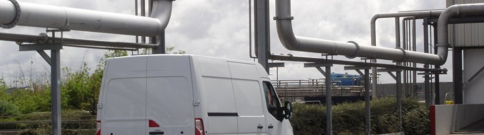
L’Unité de Production CIV16
 Notre unité de production d’une superficie de 750 m² est (...)
 -
Le savoir faire CIV16
 Créée en 1999, C.I.V. repose sur des bases solides d’un (...)
Les Réalisations CIV16
-
Chaudronnerie
 Cuverie spécifique, Vannes mécano soudée
 -
Tuyauteries Inox
 Échangeurs tubulaires, Stations de nettoyage, (...)
Notre matériel de pointe
-
Tête de soudage TIG fermée
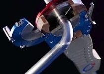 Pour le soudage tube à tube de qualité pharmaceutique avec son générateur Polysoude.

Contact :
Tél : 05 45 32 04 67
Port : 06 71 49 35 15
Actualité:
-
Vos voisins peuvent-ils couper la haie mitoyenne qui sépare vos deux propriétés ?
6
jui -
Turn-over, absentéisme, départs répétés : comment améliorer la qualité de vie au travail ? - CL’Éco
6
jui -
Facebook accuse le CBA (Cognac basket avenir) d’enfreindre la loi et supprime sa page
6
jui -
Le domicile rennais de Lucas Pouille cambriolé
6
jui

Copyright © CIV 16 - 2023 | Réalisation Anim-16 Communication Charente (16)